Rupice Maiden Resource
Bosnian Maiden Resource Estimates
23 July 2019
The Rupice Mineral Resource begins at the surface and currently extends to depths of 300m. The mineralisation remains open with significant potential to increase the size of the Mineral Resource.
The MRE is reported by classification in Table 1, with a cut-off grade of 0.6% zinc equivalent. Additional cut-off grades are shown below.
Table 1: Rupice MRE by classification including various cut-off grades
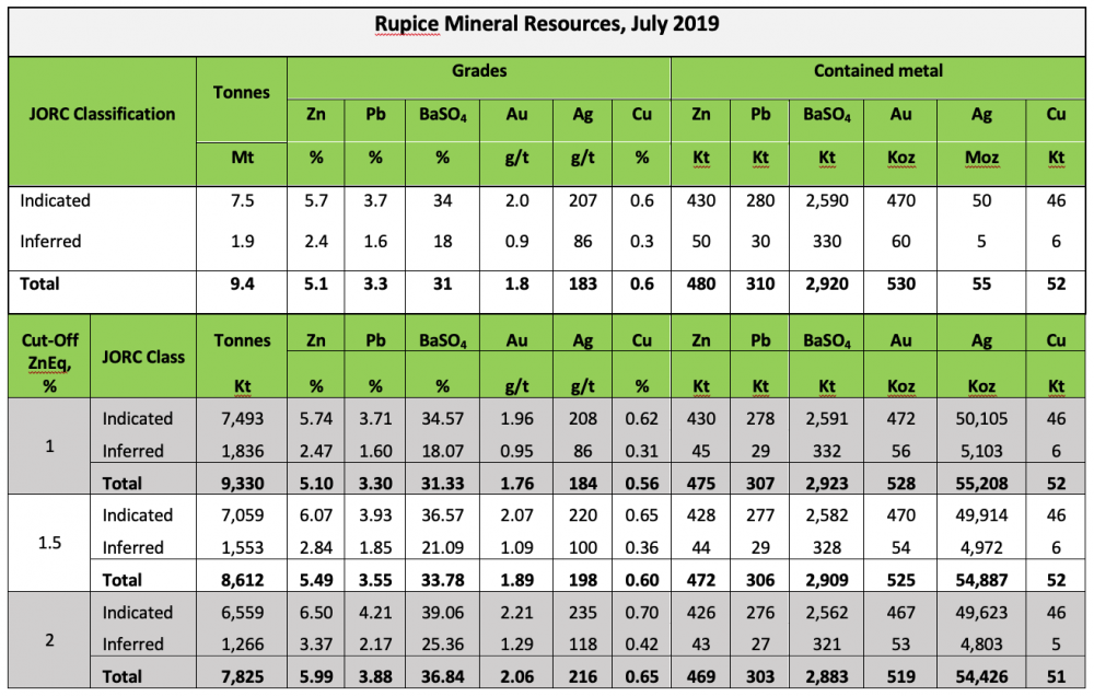
Notes:
- Mineral Resources are based on JORC Code definitions.
- A cut-off grade of 0.6% zinc equivalent has been applied.
- ZnEq – Zinc equivalent was calculated using conversion factors of 0.80 for lead, 0.08 for BaSO4, 1.80 for Au, 0.019 for Ag and 2.40 for Cu, and recoveries of 90% for all elements. Metal prices used were US$2,500/t for Zn, US$2,000/t for Pb, $200/t for BaSO4, $1,400/oz for Au, $15/oz for Ag and $6,000 for Cu.
- The applied formula was: ZnEq = Zn% * 90% + 0.8* Pb% * 90% + 0.08* BaSO4% * 90% + 1.8* Au(g/t) * 90% + 0.019* Ag(g/t) * 90% + Cu% * 2.4 * 90%.
- It is the opinion of Adriatic Metals and the Competent Persons that all elements and products included in the metal equivalent formula have a reasonable potential to be recovered and sold.
- Metallurgical recoveries of 90% have been applied in the metal equivalent formula based on recent test work results.
- A bulk density was calculated for each model cell using regression formula BD = 2.88143 + BaSO4* 0.01555 + Pb * 0.02856 + Zn * 0.02012 + Cu * 0.07874 for the barite high-grade domain and BD = 2.76782 + BaSO4* 0.01779 + Pb * 0.03705 + Zn * 0.02167 + Cu * 0.07119 for the barite low-grade domain (the barite domains were interpreted using 30% BaSO4).
- Rows and columns may not add up exactly due to rounding.
RUPICE GEOLOGY AND MINERALISATION
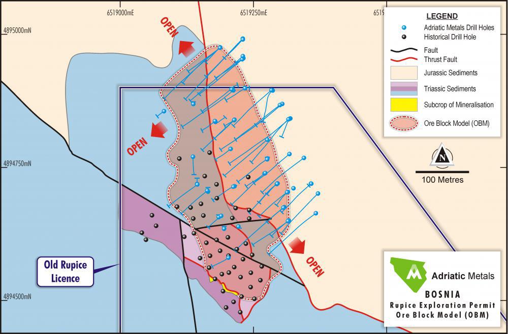
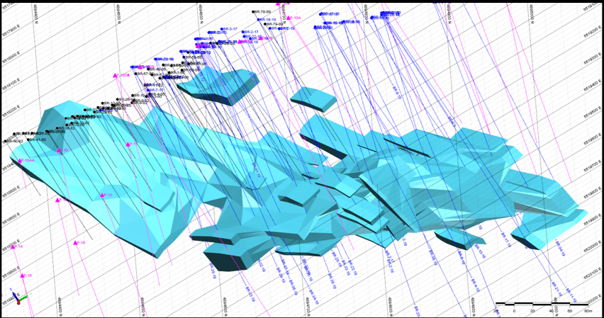
Regionally the deposit lies on a major, crustal-scale, plate convergence zone characterised by a stacked series of regionally extensive, southwest-verging nappes, bounded by shallow northeast-dipping thrusts. The local geology comprises classic and carbonate sediments of Triassic and Jurassic age (Figure 1). The Jurassic sequence comprises massive limestone and chert whilst the underlying Triassic consists of mostly interbedded shales and dolomites (grey), dolomitic shales (red), radiolarian chert (red), and fine-grained quartz siltstone and shales (grey). The red dolomitic shales form a marker horizon in the hanging wall.
Figure 1: Geology, Drilling and Outline of OBM at Rupice
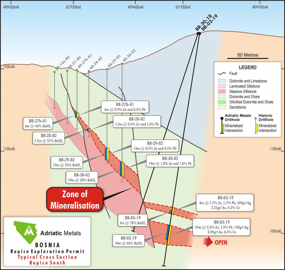
The Triassic sequence dips at around 50° to the northeast and has been intensely deformed both by early-stage ductile shearing and late-stage brittle faulting, which has resulted in a folded and thrusted (duplex ramped) sequence with thickening in a southwest direction. A typical geological cross-section to the south is shown in Figure 2.
Figure 2: Geological Cross Section - South Area
The mineralogy of the polymetallic mineralisation is relatively simple, it consists of pyrite, sphalerite, galena, barite and chalcopyrite with minor gold, silver, tetrahedrite, boulangerite and bournonite. Sphalerite is particularly light in colour suggesting that it has low iron content. The mineralisation was formed conformable to the bedding surfaces. The thickened portion occurs in a fold closure and forms a linear shoot that plunges to the north. Subsequent to sulphide deposition, steep faults formed ramps that wrapped around the mineralisation. Although its full extent is not defined by current drilling, the current extent of mineralisation is around 20m wide (measured down-dip) and can be traced for around 450m along strike. It is up to 60m thick.
RUPICE DRILLING AND SAMPLING
A total of 106 diamond drill holes (49 historical drill holes and 57 drill holes from the Company’s 2017(8 holes), 2018 (39 holes) and 2019 drilling programmes (10 holes)) for 20,295 m define the current limits of the known mineralisation. Some 87 assayed drill holes intersect the interpreted mineralisation zones which remain open to the north, south and west. The deposit was sampled using diamond drill holes at nominal 20 m spacing on 20 m northeast-southwest oriented sections. Holes drilled by the Company were generally angled –60° to – 80° towards the southwest with dip angles set to optimally intersect the mineralised bodies, whilst most of the historical holes were vertical. Diamond core has been sampled for assay; whole core for the historical drilling and half core (HQ) for the recent drilling. Recent assays were undertaken by ALS in Bor, Serbia.
RUPICE MODELLING AND GRADE INTERPOLATION
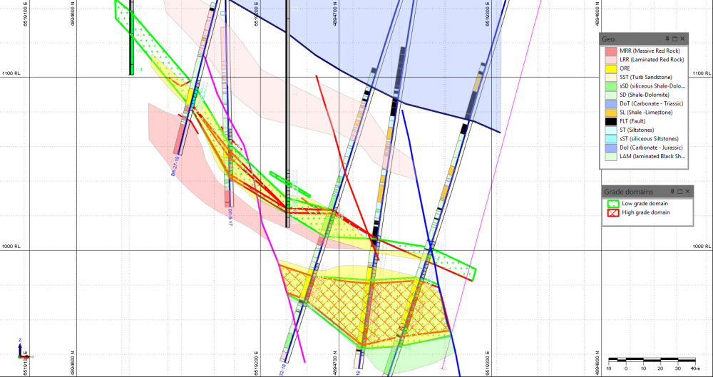
The main geological units and faults that control polymetallic mineralisation were interpreted using geological and structural logging, and were used to control the interpretation of the mineralised zones. The interpreted geological units were not wireframed, but they were used as a background as mineralised lenses were interpreted. Separate mineralisation outlines for each element were generated interactively for 17 NE-SW orientated cross-sections using individual cut-off grades that were established by the geostaHsHcal analysis. Six elements were modelled; Zn, Pb, BaSO5, Cu, Au and Ag, and four of them had two grade domains interpreted (outer ‘lower grade’ and inner ‘higher’ grade). An example of the interpretation of high and low-grade zinc domains relative to the geology is shown in Figure 3.
Figure 3: Interpretation of Zn grades - low and high-grade domains
The interpreted strings were used to generate 3D ‘solid’ wireframes for each modelled element. Every cross-section was displayed on the screen along with the closest interpreted section. If the corresponding envelope did not appear on the next cross-section, the former was projected halfway to the next section, where it was terminated. Every interpreted mineralised zone was wireframed separately and individually. All wireframe models were validated for ‘closure’ and no ‘overlapping’ triangles.
Figure 4: Wireframes for Zn, low grade domain (looking Northwest)
Once mineralisation for each element was interpreted and wireframed, classical statistical analysis was repeated for the samples within the interpreted envelopes to estimate the mixing effect of grade populations for each element, to estimate the necessity of separation of grade populations if more than one population was observed, to determine the appropriate down hole composite length and to determine the top-cut grades for each element for grade interpolation.
Geostatistical analysis generated a series of semivariograms that were used during grade estimation using Ordinary Kriging. The semivariogram ranges determined from the analysis contribute heavily to the determination of the search neighbourhood dimensions. All variograms were calculated and modelled for the composited sample file, constrained by the corresponding mineralised envelopes for each element. Where low-grade and high-grade domains were modelled, samples were combined for both domains to make sure that the number of samples was sufficient for robust geostatistical analysis. It was found that absolute semivariograms were difficult to model, and therefore, relative semivariograms were modelled for BaSO4, Ag, Au and Cu. Absolute variograms were modelled for all other elements.
The density values were calculated for each model cell using a regression formula. The formula was calculated using scattergrams for density versus BaSO4, Pb, Cu and Zn grades. The formula was calculated separately for two BaSO4 domains
A block model was constructed, constrained by the interpreted mineralised envelopes. A parent cell size of 10 m(E) x 10 m(N) x 5 m(RL) was adopted with standard sub-celling to 2 m(E) x 2 m(N) x 1 m(RL) to maintain the volumetric resolution of the mineralised lenses.
Pb, Zn, BaSO4, Au, Cu and Ag grades were interpolated into the empty block model using the Ordinary Kriging (“OK”) method and a “parent block estimation” technique, i.e. all sub-cells within a parent cell were populated with the same grade. The OK process was performed at different search radii until all cells were interpolated. The search radii were determined by means of the evaluation of the semivariogram parameters, which determined the kriging weights to be applied to samples at specified distances.
Block grades were validated both visually and statistically and all modelling was completed using Micromine software.
RUPICE CLASSIFICATION AND REPORTING
Clause 20 of the JORC (2012) Code requires that all reports of Mineral Resources must have reasonable prospects for eventual economic extraction, regardless of the classification of the resource. The Rupice deposit has reasonable prospects for eventual economic extraction on the following basis:
- All mineralisation bodies are relatively close to the surface and therefore potentially amenable to lower cost open pit mining,
- Metallurgical test work by WAI has confirmed that the Rupice mineralisation is amenable to flotation processes,
- Preliminary metallurgical test work has confirmed that a barite concentrate should meet API specifications,
- A marketing study by a leading consultant in the field of barite confirmed that there is an opportunity to enter the market as a niche player levering any logistical advantages for a supplier in Bosnia & Herzegovina,
- The cut-off grade adopted for reporting (0.6% Zn equivalent) is considered reasonable given the Mineral Resource may be exploited by open cut mining methods and processed using flotation techniques.
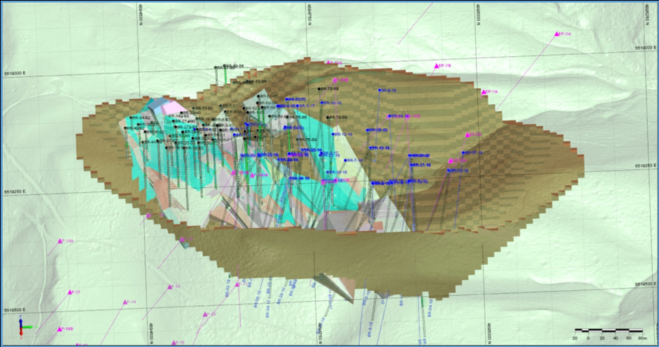
Preliminary open pit optimisation tests confirmed that the deposit has potentially positive net present value (NPV), and that almost the entire mineralised zone is potentially mineable using open pit methods under the given economic scenario and parameters. CSA Global did not estimate Ore Reserves for the deposit. The optimisation study was for the sole purpose of providing information about the mining potential of the deposit at this stage of evaluation only, and to meet Clause 20 of the JORC Code. The deposit appears to have reasonable prospects of eventual economic extraction under a realistic set of criteria. The generated ultimate undiscounted pit shell was 750m long by 480m wide and about 430 m deep (Figure 5).
Figure 5: Ultimate Pit Shell for Purposes of Clause 20 of the JORC Code (west)
The Rupice Mineral Resource has been classified based on the guidelines specified in the JORC Code. The classification level is based upon an assessment of geological understanding of the deposit, geological and mineralisation continuity, drill hole spacing, QC results, search and interpolation parameters and an analysis of available density information.